Day# 53: Silver Strand Beach
Silver Strand Beach
Oxnard, CA
Monday, August 17th 2015
Time: 53 minutes
Pace: 26:12/mile
Distance: 2.05 miles
Elevation Gain: 61 feet
Dogs Allowed?: Yes, except between 9am-5pm
Directions:
From the 101 Freeway in Ventura:
Exit Victoria Ave and head south for 6.7 miles to San Nicholas Ave
Turn Right onto San Nicholas Ave and continue for 0.2 miles to the parking lot at the end of the street.
Today was another hot day in Thousand Oaks so I headed down to Oxnard, grabbed my dog and headed down the beach. Silver Strand is almost exactly 1 mile long, so I headed from one side to the other and back again. My dog Marley loved running along the beach and meeting some other dogs along the way. It was a bit overcast and gloomy but at least that kept it slightly cooler and made for a nice walk. We even saw some dolphins on the way back to the car!
 |
| Info sign at the end of the beach |
 |
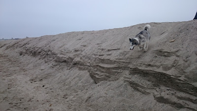
| Marley running down the enbankment |
Water Tower Service Road
Camarillo, CA
Tuesday, August 18th
Time: 1 hour, 12 minutes
Pace: 47:48/mile
Distance: 1.53 miles
Elevation Gain: 187 feet
Dogs Allowed?: Yes
Directions:
From the 101 Freeway in Camarillo:
Exit Camarillo Springs Rd and on the north side of the freeway the trail begins just before the northbound onramp to the freeway. I had to park down the road a bit to find enough space to get all the way off the road.
Today I was hanging out with friends in Ventura and needed to get my hike in on the way home. I saw some geocaches here on the map and figured this would make a good little night hike with nice views of the Conejo Grade and Camarillo at night.
I parked down the road a bit and started following the geocaches up the hill. This is a short but steep little climb to the top but the reward is great. The lights of Camarillo where great up here and looking the other way gave a great view of the cars snaking up the grade. After finding all the caches I headed back down the hill to my car.
 |
| The Conejo Grade |
 |
| Camarillo at night |

No comments:
Post a Comment